Sheriff hints at ‘after action’ review, as records reveal warning of ‘worst-case flood event’
Local officials in Kerr County continue facing public scrutiny after days of seeming to deflect questions about their preparedness and response to the July 4 flash flood that left dozens dead.
KERR COUNTY, Texas (KXAN) – Local officials in Kerr County continue facing public scrutiny after days of seeming to deflect questions about their preparedness and response to the July 4 flash flood that left dozens dead. The attention comes, as records reviewed by KXAN reveal leaders determined in 2024 that the county likely “will experience a flood event in the next year.”
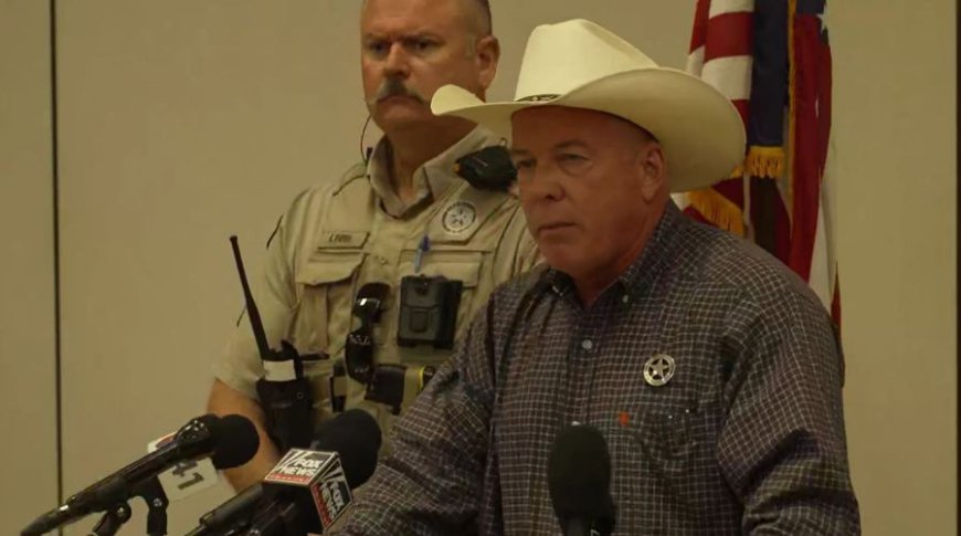
On Wednesday, during a morning press conference, they updated the death count to 95 with 161 people still missing. While again avoiding answers about specific actions in the hours between weather warnings and the Guadalupe River rising 30 feet, Sheriff Larry Leitha said there would be an “after-action” review following his “priority” of notifying victims’ families.
“We will answer those questions,” Leitha told reporters. “I wish y’all would bear with me on that, okay? Bear with me. We’ll get them. I can’t tell you when – in a week or two, okay? We’re gonna get them.”
The sheriff also assured answers for “the people that put me in this office” regarding concerns over the county’s CodeRED alerts – which allow subscribers to receive emergency notifications to their mobile devices. The effectiveness of the alerts has surfaced during press events, along with the revelation that Kerr County has no system of warning devices – like sirens – to alert the public, despite a decade of failed attempts to fund and install such a system.
Officials, like County Judge Rob Kelly, have maintained they “did not know this flood was coming,” though the National Weather Service issued a flood watch Thursday – the day before the disaster. It also issued a flash flood warning at 1:14 a.m. Friday, still hours before the river hit its height.
The county has not fully explained the timing of evacuations. At 5:31 a.m., it made an initial post on Facebook: “Be safe and move to higher ground. Do not drive through water. Turn Around – Don’t Drown!” A minute later, the sheriff’s office also reposted NWS information on its own Facebook page, adding: “If you are near the water, move to higher ground immediately. Stay clear of low water crossings – turn around, don’t drown!”
Lt. Gov. Dan Patrick has also said the Texas Division of Emergency Management communicated directly with county judges and city mayors about the weather forecast the day before the flood. At Wednesday’s press conference, Kerrville Mayor Joe Herring, Jr., said he “did not receive a telephone call” and did not know what resources TDEM had in place. He did not confirm if Kelly was part of any call.
“I wasn’t invited to the call,” Herring said. “Maybe I’m not a local mayor. I can’t tell.”
KXAN has requested a response on those claims and also a record of communication between local leaders, the NWS, TDEM and other state officials – along with any emergency notifications made – to better understand decisions regarding communication and their public warnings.
“This is the most dangerous river valley in the United States, and we deal with floods on a regular basis – when it rains, we get water,” Kelly said Friday. “We had no reason to believe this was going to be anything like what has happened here, none whatsoever.”
But a KXAN review of the county’s most recent hazard mitigation plan shows officials there have known for years flooding was a major threat in the area – and was getting worse.

Hazard mitigation plan
Under the Federal Disaster Mitigation Act of 2000, the county is required to have a Federal Emergency Management Agency-approved Local Hazard Mitigation Plan in order to be eligible for certain pre- and post-disaster mitigation funds. The latest 220-page plan was formally adopted by Kelly and county commissioners and then submitted to FEMA this April.
Stakeholders in the plan included the county, the cities of Ingram and Kerrville, the Kerrville Independent School District, the Kerrville Public Utility Board and the Upper Guadalupe River Authority. Representatives compiling the plan included both Kerr County and Kerrville’s emergency management coordinator, Kerrville’s fire chief and the UGRA general manager.
The group met twice, beginning in March 2024, and conducted public outreach in May and October that year. Their research included historic weather data from the National Oceanic and Atmospheric Administration, the county's previous hazard mitigation plan from 2018 and flood damage prevention ordinances for the county, Kerrville and Ingram each – which identified building requirements and restrictions for structures in the floodplain.
Kerr County’s emergency management coordinator, William B. “Dub” Thomas – who has held the post since November 2015 but has not been a primary part of any public appearance or press event since last week’s flood – is responsible for the “continued coordination and monitoring of the mitigation plan” during its 5-year duration. At that point, the planning team is supposed to re-evaluate and update the document, giving members an opportunity to “identify recent losses due to natural hazards and to consider whether any of those losses could have been avoided.” Thomas has not responded to KXAN’s inquiries.
The plan notes under “likelihood of future events,” the group “determined it is likely that Kerr County and participating jurisdictions will experience a flood event in the next year, meaning an event is probable in the next three years.”
Goals and objectives
The plan detailed at least 106 “flood occurrences” dating back to 1960, including the two most recently listed in 2018 – both flash floods with no injuries, fatalities or property damage. It also noted recent flooding events throughout the county have resulted in up to 10 inches of flood water and that future “worst-case flood events” could exceed those depths.
A section on “impact” said that could include:
- Residents temporarily losing power due to downed power lines;
- Motorists and residents being left stranded and needed rescue;
- Structures being flooded, damaged or even completely washed away;
- Roads being washed out;
- Emergency care centers having limited access.
While unlikely, the danger from a 500-year flood – which has a 0.2% chance of occurring in any given year – was described as “not negligible” in the plan. It also mentioned climate change could make the river flooding more frequent.
Among the plan’s main goals was reducing loss of life and injury, with specific objectives including:
- Improving the delivery and effectiveness of warning messages;
- Reducing obstacles to timely and safe evacuation of flood hazard areas.
Related to the county’s previous mitigation plan from 2018, the updated plan identified actions yet to be implemented – or in progress – but still necessary, including:
- Creating a program to educate the public about specific mitigation actions for all hazards (in progress; medium priority; estimated cost – less than $10,000 per hazard)
- Proposing a local flood warning system to reduce the potential impacts of future flood events (deferred to plan update; medium priority; estimated cost – less that $1 million)
KXAN is awaiting a response from the county about the status of the plan’s implementation and whether it was followed during last week’s flood.
What's Your Reaction?